

Madison Parish, LA
Detailed (7.5’ Quads) USGS Topographic
Maps
Detailed
topographic maps of Madison Parish are now available online. These maps,
prepared by the United States Geological Survey, are individual 7.5 minute
quadrangles and were compiled during the period 1962-1994.
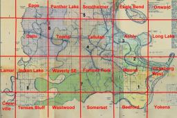
To access
these “quads” go to the Index
Map (or click on the map above) and click on the map name, such as Tallulah. A
thumbnail copy of the map will be shown to the left. Click on “HTTP”
beneath the thumbnail. This is a link to a list of files. Right click on the
.tif file (in Tallulah’s case o32091d2.tif) and select “Save Target
as...” Save and rename file to any location desired. The map file will then be
downloaded to the selected location where it can be viewed and manipulated with
almost any imaging program. Note that these TIFF files are very large, from 2
to 7 megabytes, but can be made smaller by resizing after the download.
.
Return to Madison Parish,
LA Home Page
This Page is Copyright 2010 Richard P. Sevier
- All Rights Reserved.
.