
Terrebonne Parish GenWeb
LaGenWeb
Why was the parish named Terrebonne? In the 1822 act, the name of the parish is written as two words "Terre Bonne". So it certainly seems that the intention was to name it after the meaning "good earth." Perhaps Henry S. Thibodaux used Darbonne as a starting point and altered it.
Led by Henry Schuyler Thibodeaux, whose home was in present day Schriever, Terrebonne Parish was carved out of the southwest portion of Lafourche parish. Though passed by the legislature in 1822, it would be decades before the boundary lines were settled.
Be it enacted by the Senate and House of Representatives of the State of Louisiana, in General Assembly convened, That all that tract of country, lying to the westward of bayou Lafourche, bounded as follows, to the east, from the middle of the line drawn from the lower boundary of Charles Ballot's plantation, to the lower side of Lacoupe of bayou Boeuf, thence following a line parallel with the bayou Lafourche, to within eighty arpens of bayou Terre Bonne, from thence winding round the settlement of the said bayou Terre Bonne, to the distance of forty arpens from bayou Lafourche, to be continued until a distance of eighty arpens from the latter bayou, can be effected, without encountering the limits of the lands on bayou Terre Bonne; from thence still at a distance of eighty arpens from bayou Lafourche, a line parallel with the said bayou, to the bayou Blue-Water, following whose right bank to the sea, shall terminate its eastern boudary, to the west starting from the lower side of Lacoupe of bayou Boeuf to the settlements on the Atchafalaya, and following the eastern shore of Atchafalaya bay to the sea, including Marsh island, (Isle de Marais) shall form a separate parish to be called the parish of Terre Bonne.
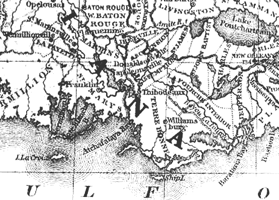
The first parish seat was located along Bayou Terrebonne, about three miles north of downtown Houma. . The first courthouse was built on the land of Alexander Dupre. A small jailhouse was also constructed. The first attempt at forming a town in Terrebonne Parish came in 1829, when William S. Watkins divided out lots in today's Bayou Cane area. After only a few lots had been sold, Watkins died. His idea for the town of Williamsburg faded away. But you can see the town on an 1839 Mitchell map.

The First 75 Resolutions by the Terrebonne Parish Police Jury The following year, Hubert M. Belanger started a subdivision further down the
bayou. Originally named Newport, it had four streets ... Main, Front, Market, and Cypress. The area became known as Canal Belanger. Shortly
after the turn of the century, the name was changed to Bourg.
If you have questions, contributions, or problems with this site, email: Marsha Holley
State Coordinator: Marsha Holley