![]()
Terrebonne Parish GenWeb
LaGenWeb
The Sanborn Map & Publishing Company compiled detail maps of cities and towns across the country in the late 1800s and the first half of the 1900s. The maps were used for insurance purposes.
The first map done of Houma was made in June 1885. It consisted of a single page of the main downtown area. It lists the population of Houma as 1200.
The two economic booms of this era were seafood (especially oysters) and lumber (especially cypress). After Baltimore, Houma produced more oysters than anywhere else in the country. Of course, agriculture (especially sugar cane) continued to be a large economic factor as it was in antebellum days.
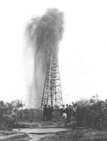 Gas & Oil
The dawn of the 20th century saw the establishment of the oil industry in south Louisiana. The gas industry soon followed. Although seafood and agriculture were still major economic factors, gas and oil became even more important.
Like communities across the country, Houma-Terrebonne contributed men, services, and goods to the war effort. Hundreds of men and women from
the area served in the war. The Houma air base served as a blimp base.
If you have questions, contributions, or problems with this site, email: Marsha Holley
State Coordinator: Marsha Holley